


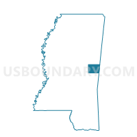
Kellis Store Voting District, Kemper County, Mississippi
About
Outline

Summary
| Unique Area Identifier | 605883 |
| Name | Kellis Store Voting District |
| County | Kemper County |
| State | Mississippi |
| Area (square miles) | 43.36 |
| Land Area (square miles) | 43.34 |
| Water Area (square miles) | 0.02 |
| % of Land Area | 99.95 |
| % of Water Area | 0.05 |
| Latitude of the Internal Point | 32.87079540 |
| Longtitude of the Internal Point | -88.74546150 |
Maps


Graphs
Select a template below for downloading or customizing gragh for Kellis Store Voting District, Kemper County, Mississippi


Neighbors
Neighoring Voting District (by Name) Neighboring Voting District on the Map
- Courthouse Voting District, Kemper County, MS
- Lynville Voting District, Kemper County, MS
- Preston Voting District, Kemper County, MS
- Shuqualak Voting District, Noxubee County, MS
- Sommerville Voting District, Noxubee County, MS
Top 10 Neighboring County Subdivision (by Population) Neighboring County Subdivision on the Map
- District 4, Kemper County, MS (2,350)
- District 5, Kemper County, MS (2,339)
- District 4, Noxubee County, MS (2,093)
Top 10 Neighboring Unified School District (by Population) Neighboring Unified School District on the Map
Top 10 Neighboring State Legislative District Lower Chamber (by Population) Neighboring State Legislative District Lower Chamber on the Map
Top 10 Neighboring State Legislative District Upper Chamber (by Population) Neighboring State Legislative District Upper Chamber on the Map
Top 10 Neighboring 111th Congressional District (by Population) Neighboring 111th Congressional District on the Map
Top 10 Neighboring Census Tract (by Population) Neighboring Census Tract on the Map
- Census Tract 301, Kemper County, MS (5,415)
- Census Tract 302, Kemper County, MS (5,041)
- Census Tract 9502, Noxubee County, MS (3,586)